
The bird atlas movement that has swept the world in the last 40 years is surely one of the great recent achievements of citizen science.
More than 400 have been published since the 1970s and it is possible more people have been involved as volunteers than in any other form of biological data collection.
But it was not birders but botanists who pioneered the biological atlas, with the now familiar grid-based dot-maps. The Botanical Society of Britain and Ireland’s Atlas of the British flora was a revelation when it appeared in 1962; half-a-century later American ornithologist Walter Ellison would describe it as the “great-grandfather of the hundreds of natural history grid-based atlases that were to follow in the next few decades as the atlas movement swept over the face of the Earth”.
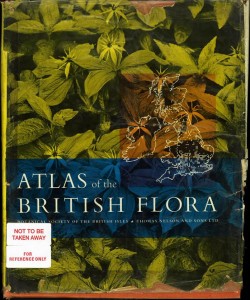
The story is nicely told in C.D. Preston’s paper Following the BSBI’s lead: the influence of the Atlas of the British flora, 1962-2012. Planning had begun in 1950 and from the start it was intended to be a scientific exercise. The atlas in fact had little impact on science, which had to wait until computers that could analyse the amount of data atlases generate became widely available, but it did have an immediate impact on conservation – leading directly to the first British Red Data Book.
Speaking at the atlas’ launch, Max Nicholson, then head of the Nature Conservancy, described it as a great leap forward. And – we can imagine the great Twentieth Century conservationist had his tongue firmly in his cheek – suggested the ornithologists had been put to shame by the botanists.
Tony Norris, another of Britain’s conservation greats, responded when he and members of the West Midland Bird Club produced the Atlas of the Breeding Birds in the West Midlands in 1970.
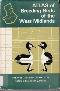
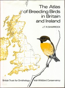
The first grid-based bird atlas, modelled on the format pioneered by the botanists, covered the English counties of Staffordshire, Warwickshire and Worcestershire, and inspired the Atlas of Breeding Birds in Britain and Ireland, organised by the British Trust for Ornithology (BTO) and the Irish Wildbird Conservancy, published in 1976.
The 1976 bird atlas was followed by The Atlas of Wintering Birds in Britain and Ireland (1986), The New Atlas of Breeding Birds in Britain and Ireland (1994), and, bringing things right up to date, the Bird Atlas 2007-11: The Breeding and Wintering Birds of Britain and Ireland (2013). The fieldwork led to any number of county and regional atlases to various parts of Britain and Ireland – a recent post on the Devon Bird Atlas 2007-2013 prompted this look at bird atlases.
Dawn Balmer, the BTO’s head of surveys, guesses at least 60,000 volunteers have contributed in Britain and Ireland alone over the last 40 years, 40,000 on the most recent atlas. Some take holidays in remote places in order to fill gaps, some make expedition-like trips to remote islands, some embark on marathon mountain bike journeys to record birds in inaccessible parts of the Scottish Highlands.
She said: “The atlas only gets finished because people do amazing things. Every time there is a new atlas you are engaging people in citizen science… it is quite addictive, people become atlas addicts.”
By the turn of the 21st Century there were also British atlases to butterflies, moths, bryophytes, reptiles and amphibians, spiders, dragonflies, molluscs, leeches and ticks. Freshwater fish followed soon after, and after that fleas, the latter the product of a 50-year labour by schoolteacher and wartime Spitfire pilot Bob George.
All stemmed from the Atlas of the British flora, which perceptive contemporary reviewers recognised had a significance beyond the British Isles.
Grid-based dot-maps were promoted by the European Ornithological Atlas Committee, formed in 1971 – the idea of using grid squares, for many years a solely military pre-occupation, had originally come from the Netherlands.
Bird atlases for France and Denmark appeared in 1976. The first American bird atlas, to Vermont, was published in 1985; by 1990 all the Atlantic coastal states from Maine to Virginia had completed fieldwork for bird atlases.
")
At the last count there were more than 400 national or regional bird atlases from nearly 50 countries, the majority in Europe and North America. There were fewer covering Africa and the Pacific, where all but one come from Australia, and only a handful from Asia, the Middle East and South America.
The original Atlas of the British flora contained another gift: it included pre-1930 records – not as far away in time then as it appears to be now – of uncommon species as open circles and contemporary records as black dots, making it immediately clear many species were in decline.
A standout feature of the 1994 New Atlas of Breeding Birds in Britain and Ireland was a huge reduction in the breeding range of farmland birds since fieldwork for the earlier atlases had been done. The 2013 atlas revealed upland birds and wading birds – according to Balmer the extent of the latter’s problems came as a particular shock – were under far more pressure than previously recognised.
“It is about the bigger picture and you only get that from having these large scale surveys periodically,” Balmer said. “It really helps you identify species which are showing the greatest change over time and it can highlight groups that are real conservation challenges.”
Browse the range of recent regional bird atlases published in the wake of the BTO Bird Atlas 2007-11.